The world’s most distant weather outpost is set for liftoff from Cape Canaveral on Sunday aboard a SpaceX Falcon 9 rocket, launching to a point a million miles from Earth to warn forecasters of solar storms that could disrupt global air traffic, satellite navigation and power grids.
The Deep Space Climate Observatory, a $340 million mission supported by NOAA, NASA and the U.S. Air Force, will detect waves of solar wind approaching Earth that could generate powerful geomagnetic storms around Earth.
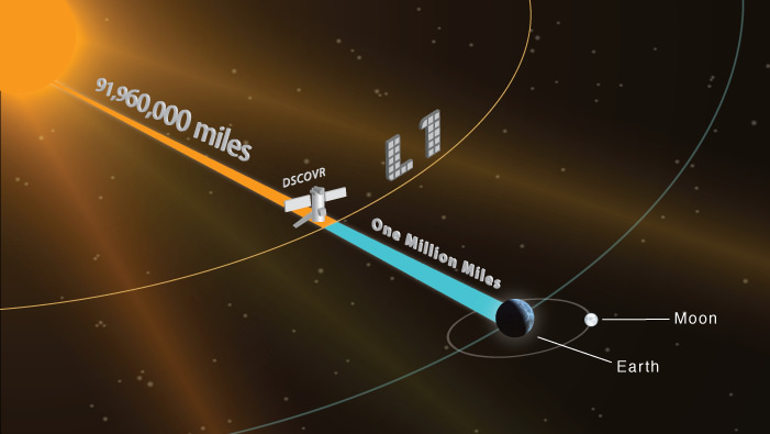
“DSCOVR will be the nation’s first operational space weather mission in deep space,” said Tom Berger, director of NOAA’s Space Weather Prediction Center in Boulder, Colorado. “It will be located at the L1 point one million miles from Earth, where it will orbit between the Earth and sun continually.”
Launch of the refrigerator-sized satellite is set for 6:10:12 p.m. EST (2310:12 GMT), and a Falcon 9 rocket will heave the 1,256-pound spacecraft on a high-speed trajectory breaking the bonds of Earth’s gravity.
Deployment of the satellite from the Falcon 9’s upper stage is planned about 35 minutes after liftoff.
“DSCOVR, when it launches, will take about 110 days to get to its observing point, which is kind of a unique place for us,” said Stephen Volz, assistant administrator for NOAA’s satellite and information service. “It’s the first deep space observer we have. It will be sitting at what’s called a Lagrange point, which is a gravitationally stable point about a million miles away from the Earth directly in line with the sun.”
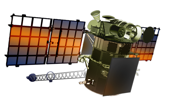
On the way, the spacecraft will extend its power-generating solar panels, deploy a boom holding a magnetometer sensor, and undergo testing of its systems and space weather instruments.
A mid-course correction maneuver is planned about 31 hours after liftoff to fine-tune DSCOVR’s path toward the L1 location, where it will again fire its engine to enter a looping halo-like orbit around the Lagrange point.
“From this location, DSCOVR will provide forecasters with critical information about the supersonic solar wind that continually streams from the sun to interact with Earth’s magnetosphere and upper atmosphere,” Berger said. “Most of us know this interaction through its generation of the aurora borealis, or Northern Lights, the most visible aspect of space weather.
“DSCOVR will also serve as our tsunami buoy in space, if you will, giving forecasters up to an hour’s warning of these huge magnetic eruptions from the sun that ocacsionally occur, called Coronal Mass Ejections, or CMEs,” Berger said.

DSCOVR’s liftoff comes after a saga stretching back a decade-and-a-half, when former Vice President Al Gore proposed a mission to produce live imagery of the full sunlit disk of Earth 24 hours a day. The pictures were to be posted on the Internet.
The mission was named Triana, after the sailor that first spotted land on Columbus’s 1492 voyage to the Americas. It was supposed to launch on the space shuttle, and was once manifested to fly on the space shuttle Columbia’s STS-107 mission, which ended with the ship’s destruction and the loss of its seven-person crew in February 2003.
But the spacecraft was mothballed in 2001 after it came under criticism from Gore’s political rivals, and NASA canceled the Triana mission 2005, citing the dwindling number of remaining shuttle flights and a lack of funding to refurbish and launch the satellite.
Engineers removed the spacecraft from storage in 2008 after officials identified the disused platform as a potential affordable way to replace NASA’s aging Advanced Composition Explorer, which launched in 1997 and is now well beyond its design life, as a source of solar wind data.
NOAA renamed the craft the Deep Space Climate Observatory, or DSCOVR, and joined forces with NASA and the Air Force to put it into space.
NASA was responsible for refurbishing the spacecraft — using funding from NOAA — and spent its own money to ready DSCOVR’s Earth watching instruments for launch. The Air Force signed a $97 million contract for SpaceX to launch the satellite on a Falcon 9 rocket.
Instead of gearing the mission toward looking back at Earth, DSCOVR will point a plasma magnetometer into the constant flow of atomic particles streaming away from the sun to measure the velocity, magnitude and direction of the solar wind’s magnetic field.
“What we’ve had is a swap of primary mission objectives,” said Steven Clarke, director of NASA’s joint agency satellite division, which oversees joint projects between the space agency and NOAA. “Triana was primarily focused on Earth observing and Earth science, with space weather being secondary, and now space weather is the primary objective for DSCOVR. We did have space weather instruments on-board for Triana, but now they become the primary objective for this mission.”

Triana’s two Earth observing sensors — a camera named EPIC and a radiometer named NISTAR — are still aboard DSCOVR. They will collect imagery and scans of the sunlit side of Earth from a new viewpoint a million miles away.
“Together these instruments will give us new insights into air quality, land cover change and climate change,” said Richard Eckman, DSCOVR program scientist at NASA.
The EPIC camera built by Lockheed Martin’s Advanced Technology Center will produce a full-color image of the day side of Earth every four-to-six hours, Clarke said, and the imagery will be posted on a publicly accessible website within 24 hours.
The camera’s more scientific purposes include monitoring total ozone and aerosols in Earth’s atmosphere, cloud height and vegetation properties in 10 narrow-band channels in ultraviolet, visible and infrared wavelengths.
“I think it will be an inspiration for people to see the sunlit disk, when they can go online and take a look at something that was just taken from a unique vantage point roughly 24 hrs before,” Clarke said.
The NISTAR instrument, manufactured by Ball Aerospace in partnership with the National Institute of Standards and Technology, will take an accounting of how much radiation is reflected and emitted off Earth. Scientists say it can help determine how much of the energy comes from human activity.
“The L1 vantage point of Earth, in which we can observe the entire sun-facing side of Earth — and all in one view — will essentially eliminate the sampling issues encountered by other low Earth orbiting satellites that are measuring the radiation budget,” Eckman said.
“This measurement should improve our understanding of the effects of changes in Earth radiation budget caused by human activities and natural phenomena,” Eckman said.
Francisco Valero, a researcher at the Scripps Institution of Oceanography in San Diego, led the original science team before the DSCOVR mission’s cancellation.
In a 2009 interview with Spaceflight Now, Valero said the mission’s holistic view of Earth would give scientists a better picture of how the planet actually works.
“I am not watching, say, San Francisco, then 10 hours later, New York, and then Denver,” Valero said, referring to how satellites in low Earth orbit make their observations. “I’m looking at the whole thing now.”
The new paradigm demonstrated by DSCOVR should be more reliable because using low Earth orbit satellites is like “looking at the forest tree by tree,” said Valero, who now works as a senior adviser and planner on the DSCOVR team, according to a release posted on the University of San Diego’s website.
Volz said the DSCOVR mission represents a “set of firsts” for NOAA, marking the agency’s first deep space observing platform and its first launch with SpaceX.
The spacecraft will beam back data on the solar wind in real-time, allowing forecasters in NOAA’s Space Weather Prediction Center to issue alerts and warnings when conditions could threaten infrastructure in communications, navigation and electrical utilities.
“As society continues to become more reliant on technology in all aspects of our lives, and because of the impact of space weather as a real threat, we must have a constant, reliable and timely flow of space environment information,” said Doug Whitely, deputy director of the office of systems development in NOAA’s satellite and information service. “With DSCOVR data replacing that of ACE, NOAA’s Space Weather Prediction Center will continue providing critical services by monitoring solar activity and providing geomagnetic storm forecasts and warnings.”
NOAA’s space weather forecast office issues “nowcasts” and alerts to more than 44,000 individuals and organizations signed to receive the notices via email. Data from DSCOVR will help scientists make forecasts for future space weather events with more geographic precision.
“Effects of space weather are wide-ranging, with potentially significant consequences. Every major public infrastructure system, including satellites, GPS, aviation and the electric power industry is at risk from space weather,” said Doug Biesecker, DSCOVR’s program scientist at NOAA.
Follow Stephen Clark on Twitter: @StephenClark1.


 Scan WeChat to give rewards
 Scan Alipay and reward


